
Section 3
Monbulk to Belgrave
8.3km
Distance: 8.3km
Elevation Gain: 314m
Walking Time: 3 hours
Food: Monbulk, Kallista, Grants Picnic Ground, Belgrave
Monbulk to Kallista is pretty much a continuation of the second half of the previous section with the trail following Sassaras Creek uphill, again following closely to a road. After passing through Kallista, stopping for a refreshement at Kallista Tea House, you will enter Sherbrooke Forest, home of tall trees and lovely forest.
Belgrave is an important hub, as the last stop of the suburban train line it marks the end of suburbia and the start of rural Victoria. It is also a busy tourism centre with the world famous Puffing Billy starting here.

Transport
Getting There
Suburban Train. Electric trains depart regularly from Melbourne city to Belgrave. The journey takes up 1 hour 15 minutes and takes you from the busy city centre out through the sprawling eastern suburbs, finishing in the foothills of the Dandenongs at Belgrave. Trains also run to Lilydale Station but this is further away from Monbulk. You can use the train and then link in with public bus to reach Monbulk. See the PTV website for timetables and details.
Bus. There are two bus services passing through Monbulk, one from Belgrave Station and another from Lilydale Station. The bus ride from Belgrave is much shorter and the better option if you are coming from elsewhere in Melbourne. See the PTV website for timetables and details.
Along The Trail
There is only one point along this section where you can access a bus. In Kallista there are buses that run to Belgrave, Olinda and Lilydale.

Day Walk
Get yourself to Belgrave by car or train then take the bus to Monbulk getting off at the Monbulk Aquatic Centre. Then walk your way back to Belgrave.

Accommodation
While there is more accommodation available in the area than on our list, these are the the places to stay closest to the trail so you don’t have to walk too far off-trail to get to your overnight stop.
$ = less than $100
$$ = $100-$200
$$$ = more than $200
For budget options take a look at AirBnB as they have a wide range of prices available. Their map view is useful to find a place to stay close to the trail.
Monbulk
There is no formal accommodation in Monbulk so if looking for a place to stay you will need to use AirBnB or continue to Kallista or Belgrave in section 3.
Kallista
Belgrave
Belgrave B&B $$$

Map
View this section on the AllTrails website to navigate your way along the route. You can also download the AllTrails App and add our routes to your library.

Route Notes
0km
Monbulk
The walk begins at Baynes Park in Monbulk with the official start about 100m east of Monbulk Aquatic Centre where Baynes Park Rd crosses Sassafras Creek. Take the track heading north (upstream). This immediate section is quite overgrown but it doesn’t last long. While there are a few intersections to navigate simply stay with the creek for the next 4km and you can’t go wrong.
There are toilets in Baynes Park, about 50m to the west towards the Aquatic Centre. There is a cafe in the Aquatic Centre if you need a snack or a coffee. The Monbulk main street and shops are east with the first shop (an Aldi supermarket) 500m away and the furthest shop 1km away from here. Monbulk has an extensive main street with multiple banks, cafes, and bakeries.
0.9km
Monbulk Rd
Emerge at Monbulk Rd. Cross over and head left to rejoin the track which is marked with an orange arrow. From here the trail stays quite close to Monbulk Rd and will take you through a series of picnic grounds that are all accessible from the road. You will also pass behind Lyrebird Fall Reception Centre.
TRACK NOTE: Around Lyrebird Falls a storm damaged bridge has been removed. The track is .passable if you don’t mind getting wet feet.
3.5km
Perrins Creek Rd
Emerge at Perrins Creek Rd. Cross over the road and go left, walking uphill. In 50m is the entrance a track to Sassafras. Do not go onto this trail, instead continue walking up to the road.
If you wanted to shorten your walk on the Dandenong Ranges Trail you could take this track to Sassafras. After 1km you would reach the 5.5km point of Section 4 which is the back entry to the Alfred Nicholas Gardens. In taking this shortcut you would miss Kallista, Belgrave, Sherbrooke Forest and the Alfred Nicholas Gardens (although you could enter the Gardens via the back entrance).
After 200m Perrins Creek Rd merges onto Monbulk Rd. Continue straight uphill and walk in Kallista.
4.1km
Kallista Tea House & Pantry
This is one of our favourite cafes on the Dandenong Ranges Trail so if the timing is right stop in for coffee and cake or lunch.
4.4km
Kallista
This point is the roundabout in the centre of Kallista. While not a large village there is a general store and cafe here.
Cross diagonally to the opposite corner of this intersection where Kallista Primary School is located. Keeping the school on your left, continue along Monbulk Rd. After 200m, at the end of the school, the trail veers left away from Monbulk Rd and enters Grants Picnic Ground. After passing through a small open area with some picnic tables go right along a path.
4.8km
Grants Picnic Ground
The cafe and souvenir shop ‘Grants at Sherbrooke’ is located here but we would say that as this cafe services the bus tourist market, better food can be found back in Kallista or wait until you get to Belgrave. Walk on past the entrance to Grants on Sherbrooke. Immediately after the shop there is a toilet on the left. Continue straight keeping Monbulk Rd on your right
After 100m there is a sign for “Margaret Lester Forest Walk”. Veer left to take this pleasant short walk which has signage along the way to explain some interesting information about the forest and history of the area.
5.2km
Coles Ridge Track
At the end of the Forest Walk come out at the car park. Turn left and walk to the end of the car park and the start of Coles Ridge Track. Continue straight onto this nice wide open track which was still used as a road until 1973. Follow this track ignoring any side tracks.
7.2km
Old Monbulk Rd
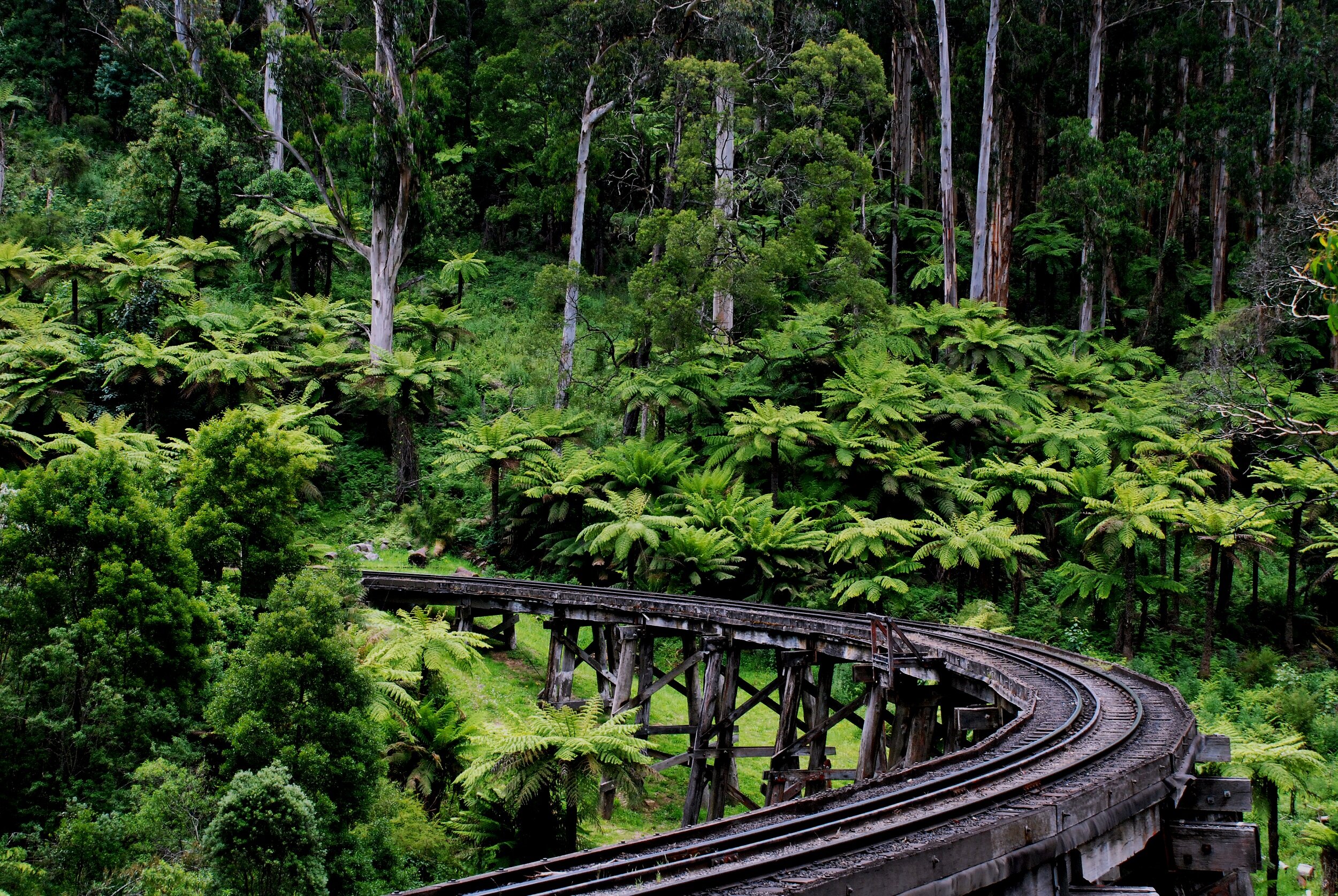
Coles Ridge Track ends at Old Monbulk Rd. Turn right to take this unsealed road that carries very little traffic. After 500m the road changes to be sealed and descends very steeply, crossing over the Puffing Billy train tracks.
7.9km
Puffing Billy Station
At the station follow the pedestrian signs to veer to the right away from the road and up a zigzag track. Once on this track do not take the straight track to Belgrave Metro Station, continue on the zigzag track. At the second straight track which is signed to “Puffing Billy Exit to Car Park” go along this track to pass under a bridge.
8.2km
Belgrave Train Station
Come out at a small bus stop station. To the right is Belgrave Metro Train Station and just beyond this the back of the shops of Belgrave main street. A ramp takes you up and over the train tracks to the main street of Belgrave. After exiting the overpass walk straight uphill on Blacksmith Way to Burwood Hwy.
8.3km
Belgrave
The corner of Blacksmith Way and Burwood Hwy marks the end of this section of the walk. Puffing Billy Cafe is here on the corner and there are plenty of other cafes and restaurants to choose from if you are looking for food or drinks. The town also has a supermarket, pharmacy, post office, and most services you could need.