
Section 4
Belgrave to Olinda
8.8km
Storm Closures:
Sherbrooke Forest that is walked on this section is currently closed due to storm damage. You will need to avoid this area by going straight from Kallista to Alfred Nicholas Gardens to avoid this section.
Distance: 8.8km
Elevation Gain: 576m
Walking Time: 3 hours
Food: Belgrave, Piggery Cafe, Sassafras, Olinda
This section takes you from the foothills of the Dandenongs, where you have been walking until now, up to the top of the top of the range and the hilltop villages of Sassafras and Olinda. This is a stunningly beautiful walk with great variety.
Starting with Sherbrooke Forest and Falls you will walk through an area known for lyrebirds. These amazing birds are both stunning to see and to hear. Their songs are a collection of the sounds of the forest. Stay quiet and listen for them as you walk but please do not venture off the trail stalking them. They are very sensitive creatures only laying a single egg each year and you can easily disturb them.
There is a great contrast to the forest as you enter the Alfred Nicholas Memorial Gardens, an historic landscaped garden. Stairs then take you up to Sassafras where you will see some of the biggest Mountain Ash trees of the whole walk. You are then up on the ridge of Mt Dandenong which takes you to the popular Olinda township. It can get busy here during the day on a sunny day, but in the evening the day trippers head home and you’ll have the village to yourself.

Transport
Getting There
Suburban Train. Electric trains depart regularly from Melbourne city to Belgrave. The journey takes up 1 hour 15 minutes and takes you from the busy city centre out through the sprawling eastern suburbs, finishing in the foothills of the Dandenongs at Belgrave. See the PTV website for timetables and details.
Bus. There are two bus services passing through Monbulk, one from Belgrave Station and another from Lilydale Station. The bus ride from Belgrave is much shorter and the better option if you are coming from elsewhere in Melbourne. See the PTV website for timetables and details.
Along The Trail
There are buses at the following points along the trail:
4.4km - 100m from the entrance to Alfred Nicholas Gardens. Buses go to Belgrave in one direction and Sassafras-Olinda in the other direction
7.1km - in Sassafras Village.
At all points buses go to Belgrave in one direction and Sassafras-Olinda in the other direction.
Getting Back
Bus. There are regular buses from Olinda to Upper Ferntree Gully Station or you can travel in the opposite direction by bus to Croydon Station. There is also a bus service from Olinda to Belgrave Station.

Day Walk
Get yourself to Belgrave by car or train and start walking. There are buses from Olinda back to Belgrave.
There are a number of places for parking around Belgrave but it can get busy here as many people drive here to take Puffing Billy. On weekends you should be able to get a park at the Belgrave Train Station. There is also parking in the large car park next to St Thomas Moore Primary School. There is a section here with all day parking but most have a two hour limit.

Accommodation
While there is more accommodation available in the area than on our list, these are the the places to stay closest to the trail so you don’t have to walk too far off-trail to get to your overnight stop.
$ = less than $100
$$ = $100-$200
$$$ = more than $200
For budget options take a look at AirBnB as they have a wide range of prices available. Their map view is useful to find a place to stay close to the trail.
Belgrave
Belgrave B&B $$$
Kallista
Ferny Creek
Sassafras
Olinda

Map
View this section on the AllTrails website to navigate your way along the route. You can also download the AllTrails App and add our routes to your library.

Route Notes
0km
Belgrave
The walk begins in Belgrave at the corner of Burwood Hwy and Blacksmith Alley. This is on the main shopping street of Belgrave.
From the corner walk north along Burwood Hwy to the roundabout. Cross over and continue straight. While this is really just a continuation of Burwood Hwy the road name changes to Monbulk Rd. There is a footpath you can walk along that winds around and finally descends to Micawber Tavern.
Note: as the west side of Sherbrooke Forest is currently closed you will need to retrace the Trail route through the east side of Sherbrooke Forest to Kallista, then walk along the road to Alfred Nicholas Memorial Garden.
1.0km
Micawber Tavern
Micawber Tavern is on the other side of Monbulk Rd, so cross over and walk in front of the Tavern to reach the car park on the north side. Walk through to the back of the car park and find the track here that will take you into Sherbrooke Forest. After 100m veer right to continue along Hillclimb Track.
2.8km
Sherbrooke Falls
On reaching Sherbrooke Falls take the stairs on the left down to walk across a bridge over Sherbrooke Falls. The falls are probably better described as a cascade but do change significantly depending on rain the last 24 hours. This was a popular destination in the 1930s with people hiking from Belgrave just as you have. After enjoying the falls, return up the stairs that you came down, then turn left.
After 200m turn right to go onto O’Donahue Track.
3.4km
Sherbrooke Track
After 400m turn left off O’Donahue Track. This is a little cut through track that leads you in 50m to Sherbrooke Track where you will turn right.
3.8km
Sherbrooke Picnic Ground
Arrive at Sherbrooke Picnic Ground.
At the picnic ground car park veer to the left to go onto a track that runs parallel to Sherbrooke Rd.
4.4km
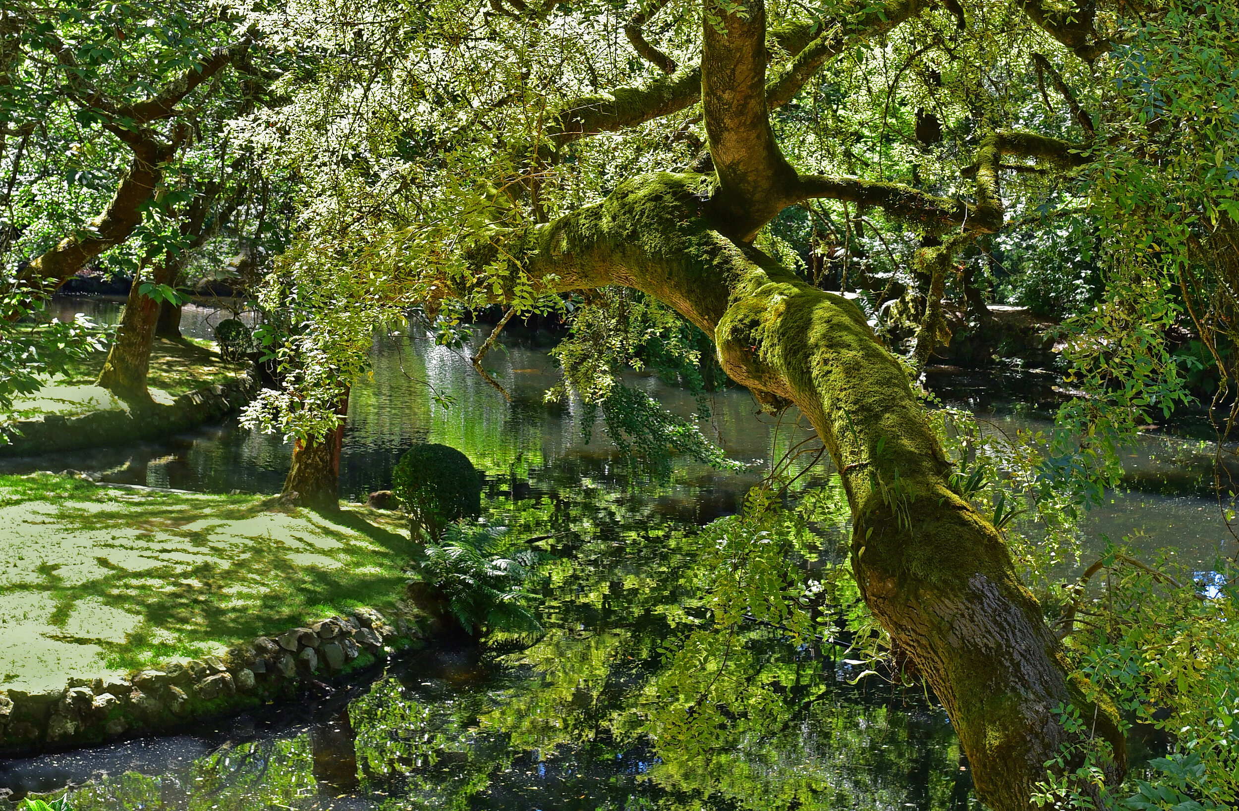
Alfred Nicholas Memorial Garden
Emerge at a car park. Turn right and cross over Sherbrooke Rd to enter the Alfred Nicholas Memorial Garden. There are toilets not too far inside the garden gates.
Alfred Nicholas Memorial Garden is the original garden of the historic Burnham Beeches estate, renowned for its extensive water features. The gardens are particularly colourful in autumn and spring, but all year round are a lovely, peaceful place to spend your time. The Gardens are open daily from 10am-5pm, closed only on Christmas Day and days of Total Fire Ban.
You could explore the gardens for hours so we leave the exploration up to you. Our route distances assume take you on a clockwise route through the garden to the back entrance at The Crescent.
5.6km
The Crescent
Exit the gardens through the gate. Between the gate and the road (The Crescent) a walking track leads to the left - follow this track. The track is single track, a little overgrown at times but easy to follow.
6.7km
Sassafras Creek Walking Track
Cross over The Crescent, the trail continues slightly to the left of the crossing point. The track is signed “Sassafras Creek Walking Track”. The trail is more steeply uphill from here. After 300m at at Y intersection veer left and start climbing the stairs. Stay on the stairs which will take you all the way up to Sassafras.
7.0km
Sassafras
The stairs will bring you out to a small car park in Sassafras Village. There are toilets here just on the right. Walk through the car park out to the main road. There are lots of shops and cafes here to explore so if the timing is right take lunch or stop for a coffee. When you are ready to continue cross over to the other side of the road and turn right to walk pass shops, cafes and Sassafras Primary School.
7.6km
Mason Gr
At Mason Gr turn left and walk uphill along the back side of Sassafras Primary School. After 100m the road ends but walk through the gate and straight onto a walking track. This is a wide open trail used by park management vehicles. After another 50m at Y intersection veer right to go steeply uphill along Sassafras Primary School Rd (not signed). The climb is hard but only lasts 400m. The landscape here is different from that experienced over the last two days. While there are still tree ferns the main eucalyptus species changes from the giant mountain ash to another type of gum tree.
8.1km
Range Rd
The uphill ends at an intersection of a number of trails and a sealed road (Range Rd). Go right to walk up Range Rd. A newly made concrete footpath makes for an easy walk.
8.8km
Olinda
Arrive at Olinda Village at the intersection of Range Rd, Everest Cr, and Mount Dandenong Tourist Rd. This section ends here.
Olinda Village has a range of food options as well as great wine shop. If you reached here by lunch and are staying nearby consider spending the afternoon at the Dandenong Ranges Botanic Gardens (formally called the National Rhododendron Gardens), home to a staggering 15,000 rhododendrons, 12,000 azaleas, 3,000 camellias and 250,000 daffodils which are clothed in colour in spring and autumn. Or even spend an extra night here and spend the day taking in the Gardens and tranquility of the area.