
Section 5
Olinda to William Ricketts
8.1km
Storm Closures:
William Ricketts Sanctuary is currently closed.
Distance: 8.1km
Elevation Gain: 320m
Walking Time: 3 hours
Food: Olinda, Skyhigh
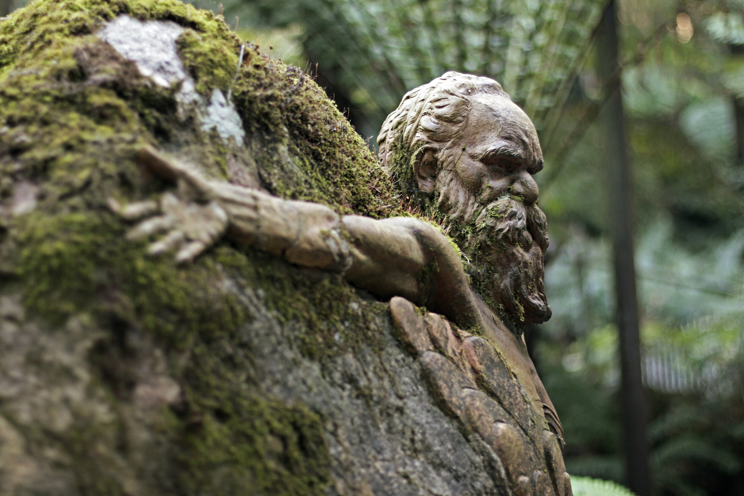
Staying around the peak of Mt Dandenong this section doesn’t travel too far but does take in one of the Dandenong’s most precious sites, the William Ricketts Sanctuary. William Ricketts spent much time living with aboriginal communities in central Australia, creating the sanctuary as a place for quiet reflection and replenishing the spirit. He believed that all Australians should adopt Aboriginal philosophies, respecting the spirituality of Mother Earth and all things in the natural world. Some of his works throughout the grounds also depict his feelings on the takeover and devastation of white man into the natural environment.
Within the sanctuary grounds, there are over 90 different sculptures depicting the Aboriginal people engaging with the earth in a pure forest setting. Carved into rocks and tree trunks that dot the paths that flow throughout the property, the themes in his artwork reflect his philosophies of connections with human, nature and the earth.
On the way to William Ricketts the trail takes you up to the peak of Mt Dandenong where you have uninterrupted views over Melbourne and Port Phillip Bay.

Transport
Getting There
Suburban Train. Electric trains depart regularly from Melbourne city to Upper Ferntree Gully/Belgrave or Croydon on the Lilydale line. The journey takes you from the busy city centre out through the sprawling eastern suburbs, finishing in the foothills of the Dandenongs. See the PTV website for timetables and details.
Bus. There are two bus services passing through Olinda, one runs in both directions between Upper Ferntree Gully Station and Croydon Station while the other is between Belgrave Station and Mt Dandenong. The bus ride from Upper Ferntree Gully is the shortest and the best option if you are coming from elsewhere in Melbourne. See the PTV website for timetables and details.
Along The Trail
There are buses at the following points along the trail:
7.6km - SkyHigh. Buses go to Olinda-Sassafras-Upper Ferntree Gully Station in one direction and Montrose-Croydon Station in the other direction.
8.1km - Mt Dandenong Arboretum. Just two stops along the same bus routes as at SkyHigh.
Getting Back
Bus. Bus 688 from William Ricketts Sanctuary goes to Olinda-Sassafras-Upper Ferntree Gully Station in one direction and Montrose-Croydon Station in the other direction.

Day Walk
If driving it is probably easiest to park at William Ricketts Sanctuary and walk or take the bus to Olinda to start the walk. If you wanted to walk it is 3km. Just follow the Mt Dandenong Tourist Rd.
On public transport you need to get yourself to Croydon or Upper Ferntree Gully Station and take the bus from there.

Accommodation
While there is more accommodation available in the area than on our list, these are the the places to stay closest to the trail so you don’t have to walk too far off-trail to get to your overnight stop.
$ = less than $100
$$ = $100-$200
$$$ = more than $200
For budget options take a look at AirBnB as they have a wide range of prices available. Their map view is useful to find a place to stay close to the trail.
Olinda
Mt Dandenong
Kalorama
These properties are after William Ricketts Sanctuary so you will have to start on Section 6 to reach them.
RiseHill House $$$

Map
View this section on the AllTrails website to navigate your way along the route. You can also download the AllTrails App and add our routes to your library.

Route Notes
0km
Olinda
The walk begins in Olinda at the intersection of Range Rd, Everest Cr and Mount Dandenong Tourist Rd. Walk downhill (north) into the small car park, through to the stairs at Loft in the Mill Hotel and into their car park. At the far end of the car park turn left onto Harold St, an unsealed single lane road.
0.4km
Dodds Rd
At the T intersection with Dodds Rd turn right. From here you will continue straight until reaching Basin-Olinda Rd. To do this after 100m you will pass through a 4WD gate and onto a walking track that descends into the forest. After another 100m continue straight again, ignoring the track veering to the left. 200m later the main track turns to the left. Continue straight (veering slightly right) on the slightly overgrown track. The last few steps down to Basin-Olinda Rd are very steep.
0.7km
Basin-Olinda Rd
At the road turn left. The road is a sealed single lane road and there are a few houses around here.
0.9km
Dandenong Creek Track
On the right is a “Fire and Emergency Access” gate. Turn right to walk downhill on this track. After 200m, just after the track turns sharply left and descends steeply, there is a track leading off to the left. Go left to go down this track. In another 300m at a T intersection turn right to go downhill on the nice wide 4WD track.
Cross over Dandenong Creek. Just before the bridge there is a 4WD track going steeply up to the right. Ignore this track and stay on the main track. The track climbs steeply at first then undulates along the side of the mountain. While there are stands of mountain ash at times in general the main trees here are the wooly gums. Stay on Dandenong Creek Track ignoring any other tracks that you see.
2.9km
Channel 10 Track
Signed intersection with Toroa Track on the right. Veer left to stay on Dandenong Creek Track. Immediately after this there is a signed T intersection at Channel 10 Track. Turn right.
3.6km
Zigzag Track
Signed intersection with Dacite Track and Zigzac Track. Turn hard right to go uphill on Zigzac Track. This is undoubtably the hardest section of the entire Dandenong Ranges Trail. The track is very steep for 1km, zigzigging up the mountain side.
4.1km
Towers Track
At the 4th switchback is a signed intersection with Towers Track. Go straight on Towers Track which climbs up even more steeply for 300m. As you climb you will see a large telecommunications tower on the right. This is the transmission tower for Channel 10 TV station. Continue on this track ignoring the track on the right.
4.6km
Bourkes Lookout
There is a great view of the city from here. On a clear day the Melbourne city centre, 40km away, is easy to see. There are two other TV towers located here.
4.9km
Kyeema Track
The track ends at a 4WD gate. A house is located to the right. Continue past the gate to a track intersection where you need to veer left through another 4WD on the signed Kyeema Track. Immediately after the gate is a memorial and info board for a plane crash that occurred here in 1938. Stay on this track ignoring Observatory Track which is 1km along Kyeema Track.
6.0km
Shortcut
Just after the intersection with Observatory Track is a small clearing. At the far end of the clearing on the right is a narrow track that leads straight up the side of the mountain. This is a shortcut to SkyHigh. There is a very small sign nailed to a tree saying “to Sky High”. While you don’t have to take this track it does save some backtracking. If going this way just go straight up the hill crossing over a larger track as you go.
6.1km
Car Park
Meet at a T intersection with Trig Track. Turn right to walk a short distance to arrive at the SkyHigh car park. Cross over the road and walk into the car park. Part way along the car park there are stairs on the right. Take these stairs up to another car park, cross over and take the next set of stairs up which will deliver you at the back of the main SkyHigh building.
6.4km
SkyHigh
Spend some time here to explore the gardens and maze (entry fee). There is a full restaurant and cafe if you are here in time for lunch. There is also a bus stop here if need transport out.
After your time is done here you need to retrace your steps back down the stairs, through the car park to Trig Track.
6.6km
Trig Track
Back at KM6.1. This is a T intersection. Turn right onto Trig Track (signed). After 50m Trig Track veers to the left, continue straight towards the road.
7.0km
Ridge Road
Pass through a 4WD gate and emerge at Ridge Road. Across the road is a sign for “Mt Dandenong Arboretum”. Cross over the road and walk directly to this sign. An overgrown track leads from here between two trees downhill through the arboretum. The track is easy to follow and as you get closer to the road becomes a single track, heads into the forest, past a huge fallen tree and out at Mt Dandenong Tourist Rd.
7.4km
Mt Dandenong Tourist Rd
When you reach Mt Dandenong Tourist Rd cross over to the other side where there is a footpath and go right.
After 600m you will pass the Williams Ricketts Sanctuary car park on the left. Do not enter the car park. Continue on the footpath another 200m to the Sanctuary.
8.1km
William Ricketts Sanctuary
William Ricketts Sanctuary is on the other side of the road. It is easy to spot but there is no obvious sign for the Sanctuary, the main sign is for “Park Victoria”. The Sanctuary is open 10am-5pm. The William Ricketts Sanctuary is a must see of the region and worth spending at least an hour exploring the beautiful sculpture and garden.
Note: The William Ricketts Sanctuary is currently closed due to storm damage.
This section ends at the Sanctuary.