
Section 6
William Ricketts to Mt Evelyn
15.7km
Storm Closures:
William Ricketts Sanctuary is currently closed.
Distance: 15.7km
Elevation Gain: 284m
Walking Time: 5 hours
Food: Mt Evelyn
The longest section of the trail is long for a reason, there are no towns or villages along the route so be sure you have supplies to get you all the way to Mt Evelyn or you will go hungry!
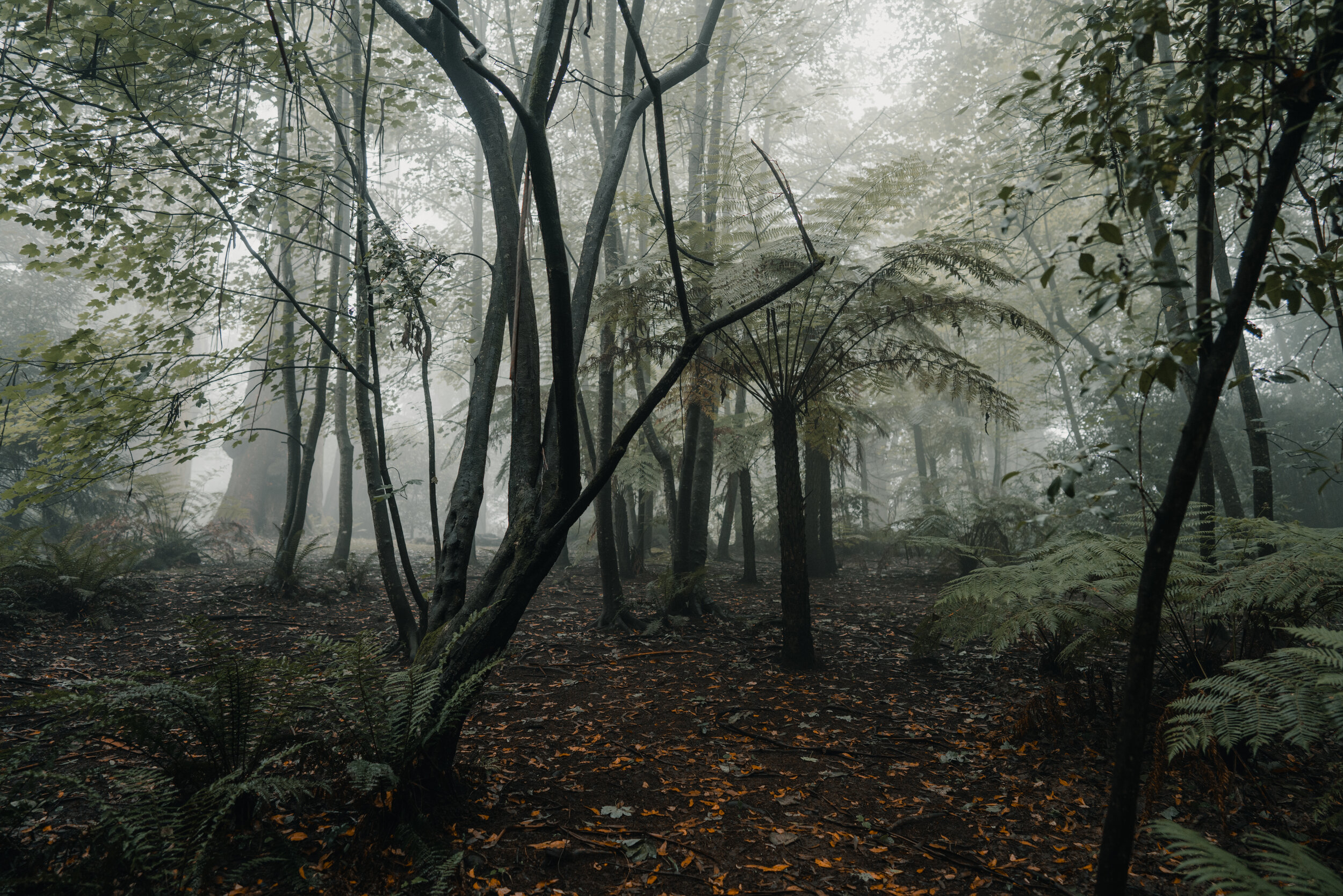
The forests of first first section of trail are again those of the massive mountain ash and fern trees. Keep your eyes and ears open for lyrebirds which we have spotted in the earlier parts of this section.
Olinda Creek will be a constant companion over the next two days as you descend off the mountain.
The trail takes you via Silvan Reservoir, part of the water supply for Melbourne. You can shorten this section by skipping the reservoir as explained in the trail notes. Beyond the reservoir a trail that follows the old aquaduct will take you to Mt Evelyn, a large hills town which also sits on the Warburton Trail, a Rail Trail which runs between Lilydale and Warburton.

Transport
Getting There
Suburban Train. Electric trains depart regularly from Melbourne city to Upper Ferntree Gully/Belgrave or Croydon on the Lilydale line. The journey takes you from the busy city centre out through the sprawling eastern suburbs, finishing in the foothills of the Dandenongs. See the PTV website for timetables and details.
Bus. There are two bus services which pass the William Ricketts Sanctuary, one runs in both directions between Upper Ferntree Gully Station and Croydon Station while the other is between Belgrave Station and Mt Dandenong. The bus ride from Upper Ferntree Gully is the shortest and the best option if you are coming from elsewhere in Melbourne. See the PTV website for timetables and details.
Along The Trail
There are buses at the following points along the trail:
9.4km & 12.3km - Bus 663 on Monbulk Rd. You need to walk a short way from the trail out to Monbulk Rd to access the bus stop. This bus travels to Mt Evelyn in one direction and Monbulk-Belgrave in the other.
14.5km - Bus 663 on Monbulk Rd. This bus travels to Mt Evelyn in one direction and Monbulk-Belgrave in the other.
Getting Back
Bus. Bus 663 from Mt Evelyn ends at Lilydale Station. In the other direction it travels to Belgrave via Silvan and Monbulk. It is not possible to travel directly between Mt Evelyn and Williams Ricketts Sanctuary. You would need to combine two buses to do this. See the PTV website for timetables and details.

Day Walk
As there are no direct connections between William Ricketts Sanctuary and Mt Evelyn you might consider driving to Lilydale, taking the bus from there towards Olinda, walking the trail, then take a bus from Mt Evelyn back to Lilydale. You could do a similar thing using Belgrave or Monbulk as your starting point.

Accommodation
While there is more accommodation available in the area than on our list, these are the the places to stay closest to the trail so you don’t have to walk too far off-trail to get to your overnight stop.
$ = less than $100
$$ = $100-$200
$$$ = more than $200
For budget options take a look at AirBnB as they have a wide range of prices available. Their map view is useful to find a place to stay close to the trail.

Map
View this section on the AllTrails website to navigate your way along the route. You can also download the AllTrails App and add our routes to your library.

Route Notes
0km
William Ricketts Sanctuary
The walk begins at the entrance to the William Ricketts Sanctuary. Cross the road and head left along the footpath in the direction you came when walking to William Ricketts on Section 5..
0.8km
Mechanics Track
Take the track leading downhill on the right. The track is clearly signed “Mechanics Track Olinda Falls 2km”. This section is a beautiful fern tree gully with massive mountain ash trees seen along the way.
After 300m crossover a dirt road and continue to follow the creek.
1.9km
Falls Rd
Emerge onto another unsealed road. Turn right and follow the unsealed road uphill.
Enter details for a detour to Olinda Falls.
2.2km
Bartlett Track
After 200m a 4WD Park management track is on the left, signed as “Barlett Trk”. Turn left here to take this track. In 100m ignore the track to the right and continue straight.
2.7km
Rifle Range Gully Rd Track
Intersection of a couple of tracks. To the right is “Rifle Range Gully Rd” and veering left is “Barges Tk”. The sign for Rifle Range is a little way around the turn so you don’t see it immediately. Turn right onto Rifle Range Gully Rd which is a single track and is a little overgrown at times. We have sighted a lyrebird in this area so keep your eyes and ears open. Ignore any tracks that branch off this track.
4.0km
Georges Track
The single track ends where a 4WD track heads off to the right. Continue straight on what is now a nice wide walking track. After 100m the track ends at an intersection with “Georges Tk”. Turn left onto a 4WD track and stay on this track ignoring any other tracks.
5.9km
Olinda Creek Rd
Georges Track emerges at the unsealed Olinda Creek Rd. Across the road and slightly to the left is “Track 13” Cross over the road and take Track 13, a wide 4WD track.
6.5km
Track 18
To the right is the signed Track 18. Turn right here and follow this track heading parallel to the river. Walk through a very nice stretch of forest through this area.
7.7km
Road
A small track leads off to the right leading about 50m to a road. Veering slightly left is signed as “Track 11”. Turn right to walk to the road.
After 100m, at the unsealed road turn left to walk along the road. There is a small walking track on the right side of the road if you don’t want to walk on the road. After another 200m pass Grey Gum Carpark on right. Continue straight, the walking track switches to the other side of the road and is signed as a horse trail.
8.1km
Silvan Reservoir Reserve
Turn right to enter the Silvan Reservoir Reserve. Follow the entry road to the left walking towards to the dam wall. 50m before reaching the wall a track lead to the left uphill towards toilets which are 50m away. At the toilets tracks continue either side of the building uphill. At the top of the track turn right to walk up into the car park. Once at the car park turn right to walk towards the lake.
8.7km
Silvan Reservoir Viewpoint
Reach the top of the dam wall of Silvan Reservoir. There is a fence here so the view is a little compromised, however it is still a nice spot to enjoy the view and look back towards Mt Dandenong and the TV Towers that you walked past earlier in the walk. Once finished here, turn around and walk back along the car all the way to the exit.
There is an exit point here where you can walk 500m to the right to Monbulk Rd and take the 663 bus to Mt Evelyn or Monbulk-Belgrave.
At the car park exit cross over the sealed road veering slightly left. There is a track running parallel to the road. Follow this track to the left passing a Melbourne Water installation.
9.1km
Melbourne Water
Immediately after the Melbourne Water installation there is a car park on the right. Enter the car park then turn to the left and walk 50m to the end of the car park where there is a gate. Walk around to the right to get through and follow the single track downhill. This track follows a large underground pipe.
9.2km
Greygum Track
Where the water pipe appears out of the ground veer right on “Greygum Tk”, a wide walking track. After 500m where the track ends at a T turn left following the sign to “Olinda Creek Tk”.
10.0km
4WD Track
Walk uphill to come out onto a very wide 4WD track. Veer right following this track to “Mt Evelyn Reserve 4km”.
10.6km
Hunter Road
On the right there is an information sign for Olinda Creek Walking Track. Behind the sign is the walking track to follow. The track descends down to Olinda Creek. As you descend ignore the two smaller tracks that lead off to the left. Cross over Olinda Creek. There is a sign just after the bridge “to Mt Evelyn Aqueduct Trail”. From here you come out to cleared land, walk past corrugated iron water pump sheds and onto the unsealed Hunter Road. Continue on the unsealed road.
11.0km
Mt Evelyn Aqueduct Trail
Turn left at the well signed start of the Aqueduct Trail and start walking on this flat wide track which is also open to cyclists and horses. The concreted aqueduct is on your left, the forest here mostly Messmate Springbark gum trees and tree ferns, and you will come across the occasional bush home. As you get closer to Mt Evelyn town, more and more houses will feature on the trail.
There is an exit point here where you can continue straight along Hunter Rd for 100m to Monbulk Rd where bus 663 will take you to Monbulk or Monbulk-Belgrave.
12.9km
Priestly Cresant
At a gate and intersection with an unsealed road turn right to follow the Aqueduct Trail sign. The track starts out as an unsealed road and reduces down to a walking track. After 200m the track turns 90 degrees to the left to go between some houses. In another 100m come out at the unsealed Priestly Cres. Continue straight to merge onto the road, heading towards the busy Monbulk Rd.
13.1km
Monbulk Road
Just before a T intersection with the busy Monbulk Rd the Aqueduct Trail goes to the left to run parallel with Monbulk Rd. The trail here sits between houses on the left and Monbulk Rd on the right.
There is a bus stop here on Monbulk Rd where you can take bus 663 to Mt Evelyn or Monbulk-Belgrave.
The trail runs parallel with Monbulk Rd for the next 1.5km so you are basically following the footpath of the road. After crossing Aqueduct Rd the trail does veer off to the left briefly before returning to be along Monbulk Rd.
15.1km
Joy Rd
Cross over Joy Rd and stay on the Aqueduct Trail. After 300m the trail turns into Gear Ave which you continue along.
15.7km
York Rd
The track comes out in the heart of Mt Evelyn on York Rd. Cross over at the lights to be at the corner of York Rd and Wray Cr.
There is a wide selection of shops here including a supermarket, cafes and many other stores. The bus stop for buses to all locations is just 100m along Wray Cr.
This section ends here in Mt Evelyn.